
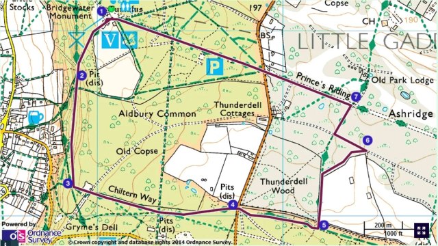
The Trust have introduced four new way-marked walks of varying length and difficulty, to supersede the existing descriptive routes. There is just one leaflet now covering the four walks with a pictorial map. On the ground the pathways are marked by roundels describing the immediate locality. Miss one roundel and you are probably lost! Getting “lost” at Ashridge is no hardship but one of those expectations – you end up seeing more of the countryside than was originally intended!
The Foresters Walk with purple roundels is a revised version of the Old Copse and Thunderdell Wood walk which covered the following three miles, now with some local interest added by the Blog.
1 Leaving the Visitor Centre behind follow the road to the left around the café and cottage and down into the tree line. When the path forks take the right hand option which descends slightly downhill following markers for the Ashridge Estate Boundary Trail.
2 When the track forks again take the left hand option to continue ahead on a level, well-made path, still following the Boundary Trail. Continue for about ½ mile (800m) until arriving at a junction with a telegraph pole. The Trust intend to open up the view to the right overlooking the ancient village of Aldbury as part of their twenty year Woodland Plan.
3 At the junction turn left passed Old Copse Lodge which dates to around 1813 when the road from Aldbury was built to give access to the Mansion from the West. Cross a hard-surfaced road onto a well-surfaced bridleway continuing straight ahead for about ½ mile (800m), ignoring any cross paths and eventually arriving at a main road. Before the road note the huge clay pit to the left used for brick and tile making in the 17th century.
4 Before crossing over the road which is particularly busy, note the “laid” hedge on the left recently restored by the volunteers which forms the road boundary for the Old Dairy Farm once owned by Elizabeth 1st – a favourite spot for the grazing fallow deer. After crossing the B 4506 you will be in a small pull-in car park. Behind the car park take the bridleway to the left which is the well maintained path-way known as Lady’s Walk. It runs between two notable soil banks. Proceed straight ahead until an open field comes into view on the left – this is part of the original deer Park landscaped by Capability Brown in 1760 for the Bridgewater family.
5 At this point turn left following the footpath around the field. The route deviates from the main paths so continue to follow the fence line around the field until arriving at a hard-surfaced track.
6 Turn left onto the track and continue to a junction with another surfaced road then turn right onto this new road.
7 Follow this road until it crosses a broad, grassy avenue which is known as Princes Riding – King Edward V1 and his sister Elizabeth 1st grew up at Ashridge. Turn left onto the avenue and walk towards the Bridgewater Monument to be seen in the distance. Before starting off take a look at Old Park Lodge over to the right built in 1619. Before reaching the Monument you should look back along the riding and view the new Mansion completed in 1813. It was built in the Gothic style and replaces the original monastery built in 1283, dissolved in 1538 and retained as a royal palace until 1604.
